The long awaited official
forecast of the Indian Meteorological Department (IMD) was finally announced last Thursday evening. The IMD released their report the same day when the
Cabinet considered clearing a Rs 400 crore Monsoon Mission to update meteorological
techniques in the country by which the Indian monsoon could be predicted. This
being so as the monsoon being one of the toughest weather phenomena to map.
The country is set to receive normal South West Monsoon
rains in 2012, for a third year in a row. “It
is a normal forecast,” said Mr Vilasrao Deshmukh, Union Minister for
Science and Technology.
“Quantitatively, the monsoon season
rainfall is likely to be 99 per cent of the long period average (LPA) with an
error margin of 5 per cent,” IMD said.
The LPA pegged at 89 cms is the average
of the seasonal rainfall over the country as a whole from 1951 to 2000. The
onset date for monsoons will be revealed by IMD sometime in middle of May.”
The IMD’s April
forecast used five predictors, four of which reflect atmospheric conditions in
the Pacific, Atlantic and Indian Ocean. The fifth is snow cover in Europe. An
updated forecast will be made in June. “Out
of five parameters, one (Indian Ocean sea surface temperature) is favourable
and one (north Atlantic SST) is unfavourable. The rest are neutral at the
moment,” said D S Pai, an IMD scientist, quoted by Deccan Herald.
A forecast of normal rainfall at 99% of LPA should
be reassuring news for India where the monsoon is the lifeline
of a farm-dependent economy. But as they
say “The
devil is in the details”.
So what’s the fine print? These read as follows:
(a) Southwest monsoon
seasonal rainfall for the country as a whole is most likely to be Normal
(96-104%) of Long Period Average (LPA)) with the probability of 47%. Quantitatively,
monsoon season rainfall is likely to be 99% of the LPA with a model error of ±
5%. The LPA of the season rainfall over the country as a whole for the period
1951-2000 is 89 cm.
(b)
The probability (24%) of season rainfall to be below normal
(90-96% of LPA) is also higher than its climatological value.
(c)
However,
the probability of season rainfall to be deficient (below 90% of LPA) or excess
(above 110% of LPA) is relatively low (less than 10%).
In our monsoon
forecast this year (read here), we predicted a “Normal Monsoon” with a probability of 70% which we still maintain as
of today. Our forecast is very close to those of a local private weather
forecasting firm Skymet, who predicted a normal monsoon this year. "There are 80% chances of a normal
monsoon and 20% of an above-normal monsoon," said Skymet CEO Jatin
Singh to the Economic Times.
In contrast the
IMD’s forecast of a “Normal Monsoon” lacks
a high confidence level as they preferred to actually hedge their bets. While assuring
normal rains, Earth Sciences Secretary Shailesh Nayak said a lot depended upon
the distribution of rainfall.
However, as the Business Standard noted - reading between the lines, two facts
emerge: one that the probability of “normal”
rains at 47 % is lower than around 51%, issued last year, and two, the
likelihood of “below normal rains” at
24% is higher than that of 20% during 2011.
It is possible that
the IMD buckled under pressure when many international weather models
forecasted the possibilities of the monsoon failing. Just being the official
agency for prediction of the Indian monsoon is bound to create additional
frayed nerves. Their chequered track record accentuates the pressure further. Particularly
so as it is the first time the IMD has taken into its statistical model, inputs
of a new dynamical model.
"It's
little early to predict the nature of monsoon. The real assessment can be done
in the last week of May. We have seen predictions failing several times.
Experts failed to forecast the drought in 2009 and instead predicted normal
rains. The rainfall was 23% below normal," said an IMD official to Economic Times.
However,
theoretically, the IMD may have just played by the book. Ed Lorenz showed in
his simple 3-variable model the Chaos Theory that forecasts are an initial
value problem. The forecast prediction is sensitive to conditional sensitivity;
a small perturbation in the initial conditions can lead to a large change in
the forecast.
LS Rathore, Director
General, IMD in his interview with CNBC-TV18 explains:
How
real is the El Niño Threat?
Based on the key El Niño
Southern Oscillation (ENSO) parameters (SST; SOI, Trade Winds and Cloudiness)
as on ending 3rd week April, ENSO neutral conditions exists as of present.
According to the latest Bureau of Meteorology (BoM), Australia data, this is how the El
Niño parameters are faring up:
SEA
SURFACE TEMPERATURES (SST)
The latest sea surface
temperature (SST) in the central and eastern equatorial Pacific Ocean shows
that it warmed during March. However, the SST anomaly map for March shows SSTs
were near normal across most of the tropical Pacific. Small areas of warm
anomalies more than 1 °C warmer than usual are present in the far east,
near the equator and along the South American coast.
In short, the SST signal in
the central and eastern equatorial Pacific Ocean is clearly within ENSO neutral
values.
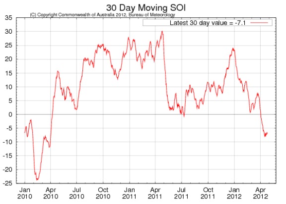
SOUTHERN
OSCILLATION INDEX (SOI)
The Southern Oscillation
Index (SOI) at -7.1, though ENSO neutral, is just a tad below El Niño threshold
levels. The SOI values are not seen since April 2010 at the end of the last El
Niño and primarily the reason for fuelling the speculation of an emerging El
Niño event in the coming months.
[Sustained positive values
of the SOI above +8 may indicate a La Niña event, while sustained negative
values below −8 may indicate an El Niño event. Values of between about +8 and
−8 generally indicate neutral conditions.]
TRADE
WINDS
Trade winds have strengthened
over most of the tropical Pacific over the past two weeks. Easterly wind
anomalies are again in place over the western tropical Pacific and the eastern
tropical Pacific south of the equator, with trade winds in the central region
and north of the equator in the east near normal.
[During La Niña events, there is
a sustained strengthening of the trade winds across much of the tropical
Pacific, while during El Niño events there is a sustained weakening of the
trade winds.]
The trade winds therefore remain within
ENSO neutral values.
CLOUDINESS
Cloudiness
near the dateline has declined from slightly enhanced to weakly suppressed over
the past two weeks. So cloudiness is ENSO neutral leaning more to La Niño
thresholds.
[Cloudiness
along the equator, near the Date Line, is an important indicator of ENSO
conditions, as it typically increases (negative OLR anomalies) near and to the
east of the Date Line during an El Niño event and decreases (positive OLR anomalies)
during a La Niña event.]
MODEL FORECASTS
The
Predictive Ocean Atmosphere Model for Australia (POAMA) model forecast of the
El Niño - Southern Oscillation (ENSO) can be found below:
May Jun
Jul Aug Sept
Oct Nov
Outlook for month NINO34
(°C) 0.24 0.27
0.40 0.47 0.52
0.55 0.57
The mean ensemble
suggests that August-September is where El Niño threshold values are possibly reached.
Research has shown the ENSO cycle, involves a circum-global teleconnection
(CGT) pattern in the Northern Hemisphere observed in association with Indian
monsoon rainfall anomalies. The ENSO also affects the wave structure of the CGT
by modulating the strengths of the Indian Monsoon. As a result ENSO affects the
extra-tropical circulation during the boreal summer by relocating the monsoonal
heat sources. So it is easy to understand why IMD is hedging their bets by
playing safe by not ruling out the emergence of a new El Niño.
[Boreal summer refers to
the summer in the northern hemisphere. Boreal summer months are June, July,
August, and September]
It must be however noted
at a meeting in Pune earlier this month of the South Asia Climate Outlook Forum
(SACOF), a World Meteorological Organisation (WMO) - linked body representing a
region with a common monsoon cause and shared worries, said that the northwest
and southern parts of the Indian sub-continent could receive below-normal rains
this year.
“Though
the consensus outlook indicates the summer monsoon rainfall for the entire
South Asian region is likely to be within the normal range, there is also a
slight tendency for the rainfall to be below normal,” the forum had said in its
report.
It added there was a likelihood of below-normal rains
over some areas of northwestern and southern parts of South Asia. The areas
SACOF said were likely to receive below-normal rains this year included India’s
primary food grain growing regions of Punjab, Haryana, western Uttar Pradesh
and parts of Tamil Nadu, Kerala and Karnataka.
"There is also noticeable probability
(about 39%) for emergence of weak El Nino conditions during the later part of
the monsoon season. However, the probability of re-emergence of La Nina
conditions during the monsoon season is very less," the IMD said.
D Sivananda Pai,
head of IMD’s long-range forecast in an interview with the Business Standard
further clarified:
“The possibility of
the El Nino cannot be ruled out this year. But here, the only crucial aspect is
the timing. Whether it would come late in the four-month monsoon season, or
during the mid-season, remains to be seen. But, yes there is a possibility of
the El Nino.”
In our initial forecast of
the monsoon (read here), we assumed the El Niño would not be a significant
factor and we continue to treat it as so for the following reasons:
a.
It is during the months of August and
September we could see the maximum impact, if any, but with mean ensemble projections
around 0.5 deg C, borderline in El Niño threshold value; its impact should be
fairly negligible.
b.
It is to be kept in mind that though the El
Niño is a significant factor for below average or deficient rainfall, it is
nevertheless not an essential condition.
[During
the period 1875 to 2009, there were 37 El Niño years. Out of these 37 El Niño
years, monsoon was deficient (below 90% of the long period average), during 16
years, In 14 years, the rainfall was between 91 to 100% of long period average
and during the remaining 7 years, rainfall was between 101 to 110% of long
period average.
This
shows that there is strong probability (nearly 81%) that rainfall will be on
the negative side of the normal. It is important to note that El Niño is the
most important factor that causes the deficient rainfall over India. Out of the
22 deficient years during the period 1875 to 2009, 16 years (73%) were
associated with the El Niño. The remaining 6 deficient monsoon years (eg. 1968,
1974, 1979 etc) were not El Niño years.
The
above statistics also shows the absence of one to one correlation between El
Niño and deficient monsoon.]
According to the POAMA mean ensemble, we could see the
onset of the next El Niño by early September. If so, this would be advantageous
as an El Niño favours a more bountiful North East Monsoon. So any deficient
rainfall during the South West Monsoon season can be expected to be easily made
up by the North East Monsoon on an annualized perspective. Besides, an El Niño
event typical lasts 9-12 months and consequently a September onset for the next
El Niño could result in a normal monsoon for the 2013-2014 season.
Sea surface temperature (SST) in the central and eastern
equatorial Pacific Ocean tends to typically warm up during the boreal summer
and so we are only able to get a real confirmation of an El Niño emerging this
year by as late as September end, the very earliest. But with large tracts of
Maharashtra, Andhra Pradesh and Karnataka already reeling under drought like
conditions it does seem to increase the likelihood of an El Niño by September
as these affected regions are typical of those affected by drought during an El
Niño year. Many see these droughts like
conditions as advance signals of an emerging El Niño.
Could the Indian Ocean
Dipole (IOD) be the Wild Card?
The IMD forecasts did not mention any threat to the
monsoon on account of the IOD, a temperature seesaw between eastern and western
coastal waters of India. So we are not too sure if the IMD has factored in fully
this possibility within its 2012 monsoon forecasts. We on the other hand
considered the IOD as a possible wild card to the monsoon this season. In the
absence of a strong ENSO influence, it is the IOD that assumes the role of the
major driver of the monsoon.
So did the Regional Institute of Global Change (RIGC),
Tokyo who forecasted a deficient monsoon primarily on the back of a negative
IOD.
[While a positive IOD helps the monsoon, a negative
value has adverse impact].
The POAMA model forecasts of the IOD are given below:
In contrast to the El Niño,
which is likely to be unfavourable to the monsoon for the months of Aug-Sept, a
negative IOD should be unfavourable to the months June-July. But since the IOD
is only very weakly negative its impact on rainfall should be fairly minimal.
“The
IOD is negative, which is not good for rainfall. But it’s a weak IOD that can
be overcome by other factors. In any case, IOD comes into play only late in the
monsoon season, around August-September,” M Rajeevan, adviser
to the Ministry of Earth Sciences and former monsoon forecaster with IMD told
Deccan Herald.
Notice the variance of IOD
outlook of the IMD and POAMA. While the POAMA model suggests a negative IOD
during June-July, the IMD outlook puts it around August-September. By itself
neither a weakly negative IOD nor an El Niño may not pose a significant threat to
the monsoon. But this maybe another matter if they coincident and reinforce
each other in effect.
THE THREAT OF
INSUFFICIENT HEATING ANOMALY
Climate alarmists may
foolishly tout the heat waves as evidence of global warming. But these are a
usual occurrence in northwest India as well as central and east-central India
during summer. Extreme heating of this kind is what helps put the right
temperature/pressure gradient into place relative to the ocean. The monsoon
rides this gradient from the southwest.
Monsoons, or rainy seasons,
are a shift in wind direction which causes excessive rainfall. Winds
originating over a body of water are called maritime. This moist ocean air is
what causes monsoonal rains. Differential heating occurs when the sun heats the
land and oceans. Incoming solar radiation heats landmasses faster than large
bodies of water. In tropical climates, solar heating is most intense in the
summer months. As the land heats up throughout the summer, a large low pressure
system builds over the land.
The heat from the sun also
warms the surrounding ocean waters, but the effect happens much more slowly due
to the high heat capacity of water. Therefore, the ocean temperatures as well
as the layer of air above the oceans stay cooler longer. The cooler air above
the oceans is moist and denser, creating a high pressure zone relative to the
pressure above the landmass. Winds flow from high pressure areas to low
pressure areas due to the pressure gradient. The heat/pressure differential
decides the strength with which the lower pressure over land can pull in south-westerly
monsoon flows from sea.
There are as yet no signs
of such heating happening. No sustained heat waves have been reported either
till date, with core heating confined to central and east-central India. So
some experts are of the opinion that Northwest India and East Equatorial Indian
Ocean may have a big say on the fate of the 2012 monsoon.
Due to the residual La Niña
effect, temperatures have been largely pleasant this summer in large parts of
the country. Western disturbances (Westerlies) have been above average bringing
thunderstorms, cooling the land masses.
A clutch of global forecast
indicates that ‘sustained and purposeful’
heating would begin by only the second week of May. This is based on the
assumption that the frequency of contra-indicative western disturbances would
wind down by that time. This too is the assumption that IMD forecast basis
itself.
But other models suggest
that the mercury may not peak to a level where it could trigger dreaded heat
waves - 45 deg C + - in any part of the country. But IMD Chief, LS Rathore
discounted its significance:
“Similar
conditions during May were also observed during 2008, the year that saw good
rainfall.”
Rathore should be on the
spot. It is not important whether heat wave in the northwest, central and
east-central India occurs as typically. What matters more is whether the differential temperature or Δ
(delta) between land and oceans assumes criticality as required:
It has to be kept in mind while temperatures of land masses
maybe below average, so are the Sea Surface Temperatures (SSTs) due to the
negative IOD. As long as the Δ (see figure) temperature differential assume criticality, there should be
little cause of worry on its adverse effect on the monsoon.
IMD frittered away an
opportunity to redeem itself
The old saw about the weatherman looking at the skies
to tell you whether it will rain or not is quite true. Six years ago, it even
adopted a new and improved monsoon forecasting model, but its predictions have
gotten worse and worse.
Last year it began with the forecast of a 'normal'
monsoon on 19 April. Two months later, IMD revised this to ‘below normal’. Last August had been the wettest in 15 years – with
rainfall being nearly 10 percent above normal. The IMD was wrong about August
not by a few inches, but a mile. In its long range forecast update on June 21,
the IMD had said that rainfall in August was likely to be 6 per cent below
normal, with a model error of plus or minus nine per cent. Six percent below
normal means 94 percent of the LPA. But since it was 9.9 percent in surplus, it
means the actual figure was closer to 110 percent of normal. That’s a huge 16
percent off the mark – well beyond the stated potential error of plus or minus
9 percent.
With its credibility at stake, with nothing to lose
and armed with its new dynamic model, the IMD should have stuck its neck out and
predicted a “normal monsoon” with a
confidence of 80% plus. It had an opportunity of proving global model
projections wrong and hit a high in its image. But it shied away from this
challenge and instead hedged its bet suggesting a low confidence level in their
own institutional capability. So even if they proved right by their "Normal Monsoon" forecast, hedging their bets would take
way most of the glory in the event if they get right their forecast. That's a tragedy.
Other related
archived posts, click title to read:
Monsoon
onset seen around normal date
The summer
heating of the Indian sub-continent begins
Official
Monsoon forecast disappoints: The IMD plays safe, hedges its bet!
South Asian
Climate Outlook Forum-3: Monsoon likely to be below normal over south and
northwest India
Vagaries of
Weather: Monsoon Watch-2
India sees
2012 monsoon normal, no El Nino threat
July rains could fail India, says Japanese model